🕑 Reading time: 1 minute
Drone surveying is an aerial survey conducted using drones and special cameras to capture aerial data with downward-facing sensors. It is frequently used by surveyors and engineers in construction for terrain assessments and mapping.
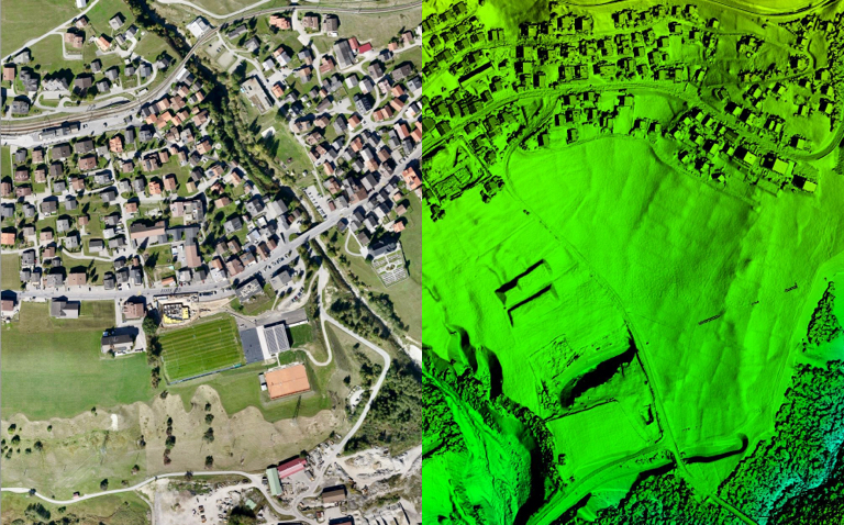
Image Credits: Wingtra
Drone surveying can be 90% faster than manual surveying methods. It helps in creating highly accurate maps and survey points. In addition to surveying, firms also use drone mapping to identify job-site errors, track work progress, predict schedule delays, etc.
This article details the features and applications of drone mapping and surveying in the construction industry.
Features of Drone Mapping and Surveying
- During drone survey, the ground is photographed several times from different angles, and each captured image is tagged with certain coordinates.
- The collected data are processed using drone mapping software to create construction assets like 3D models, 2D maps, digital elevation models, from which highly accurate measurements and volumetric calculations are taken.
- Drone captures highly precise data quickly, without the need for surveying staff to walk over dangerous terrain or height to collect the information.
- The two common types of drone mapping methods are photogrammetry and LiDAR.
- Photogrammetry involves capturing high-resolution images that are later processed and stitched using sophisticated software to recreate a survey area in the form of measurable 2D maps or 3D models.
- LiDAR sends pulses of light to the earth's surface to detect small objects during drone mapping.
- The drones in drone mapping consist of Red Green Blue Visual Imaging (RGB) for photogrammetry, thermal, LiDAR, or multispectral sensors to capture aerial data.
- The different maps or deliverables obtained from drone surveying are orthomosaic maps, Digital Surface Model (DSM), Digital Terrain Model (DTM), and contour line maps.
GCPs, PPK, and RTK in Drone Surveying
For very precise drone surveying, it is necessary to accurately locate the position of a drone in flight. This can be done either using Ground Control Points (GSPs), Real-Time Kinematic Survey (RTK), or Post Processing Kinematic (PPK) survey.
GCPs are reference points present in the ground whose coordinates are already known. GCPs enable the drone to return accurate data about its location and the distance it traveled between the two places. As laying GCPs on the ground is time-consuming and requires labor, vehicles, equipment, and lots of paperwork, techniques like PPK and RTK have been developed.
RTK is a GPS correction technology in which the location data of the drone is provided real-time corrections during the drone surveying and image capturing process.
PPK surveying is a GPS correction technology that corrects the location data of the drone only after the complete survey data is collected and uploaded. It is performed post the site work.
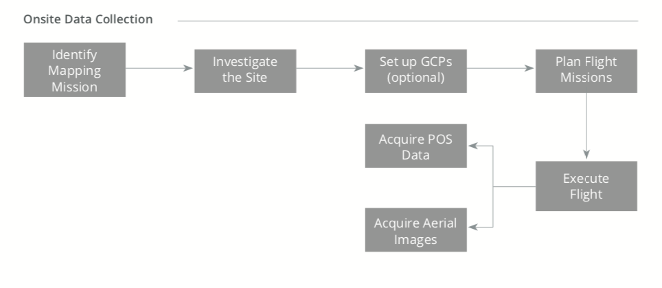
Image Credits: DJI Enterprize
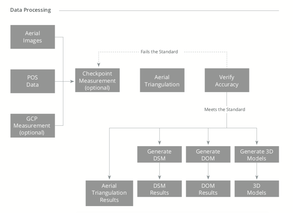
Image Credits: DJI Enterprize
Applications of Drone Surveying
The main applications of drone surveying are in:
- Land surveying
- Precise measurements
- Land management and development
- Volumetric measurements
- Slope monitoring
- Urban planning
1. Land Surveying/Cartography
Drone surveying generates high-resolution orthomosaic maps and 3D models of areas to create accurate cadastral maps. It provides information on a site with low-quality/outdated/no data available.
2. Land Management and Development
The aerial images obtained from drones simplify topographic surveys for land management and planning. It facilitates site scouting, allotment planning, design, and the final construction of roads, buildings, and utilities. In addition, the data is used for pre-construction engineering studies transferred to CAD or BIM software to work with 3D models.
3. Precise Measurements
The surveyors can perform highly-accurate distance and surface measurements using the high-resolution orthomosaic photos from drone surveying.
4. Volumetric Measurements
The images obtained from drone surveying can be used in 3D mapping software, from which volumetric measurements are obtained. The method is used primarily for calculating stocks in mines and quarries for inventory or monitoring purposes.
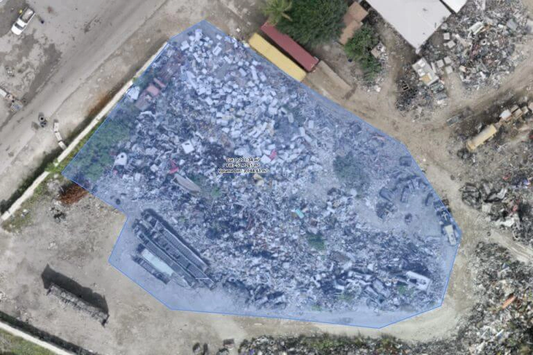
Image Credits: WINGTRAONE
5. Slope Monitoring
The DTMs and DSMs generated by drone imagery and GIS analysis enable the extraction of slope measurements. Moreover, in some site conditions, the orthomosaic maps are generated at different times to detect changes in the earth’s movement and measurement of velocity. This method, hence, helps in slope monitoring for landslide mitigation and prevention, for example, predicting landslides, preventing potential damage to roads, railways, bridges, etc.
6. Urban Planning
Drone surveys help urban planners collect up-to-date data of a complex urban area quickly using less staff to study the existing social and environmental conditions of the sites. This makes the planning stage of the development of an urban area easier.
FAQs
Drone surveying is an aerial survey conducted using drones and special cameras to capture aerial data with downward-facing sensors.
For very precise drone surveying, it is necessary to accurately locate the position of a drone in flight. This can be done either using Ground Control Points (GSPs), Real-Time Kinematic Survey (RTK), or Post Processing Kinematic (PPK) survey.
The DTMs and DSMs generated by drone imagery and GIS analysis enable the extraction of slope measurements. Moreover, in some site conditions, the orthomosaic maps are generated at different times to detect changes in earth’s movement and measurement of velocity. This method, hence, helps in slope monitoring for landslide mitigation and prevention
Read More

